Address:
Killybegs Harbour Centre,
Killybegs,
Co. Donegal
Lárionad Chuan Na gCealla Beaga,
Na Cealla Beaga,
Co. Dhún Na nGall
Phone: +353 74 97 31032
Fax: +353 74 97 31840

A Survey of Killybegs Harbour was carried out by the Marine Engineering Division of the Department of Agriculture Food & the Marine. There were 2 components to this survey - monitoring of air by gas meter and inspection of seabed by diver.
Following concerns about noxious gases escapes from waters in the harbour area, the marine engineering division recommended a monitoring exercise to carry out regular measurements of gas levels close to the water surface over a defined period and at a number of sampling points.
This monitoring exercise was carried out by marine engineering division personnel in weeks beginning 18/3/13 and 25/3/13. It involved checking for a range of gases using the Department owned gas meter at 13 specific points at the berths in the harbour ( see attached DAFM drawing titled "Gas meter check survey locations"). Gas levels at these points were checked twice daily. The gas meter (Altair 4 model) allowed checking for the presence of hydrogen sulphide, combustible gases and carbon monoxide and for checking for abnormal oxygen levels. Measurements were taken at quay surface level and at 0.3 metres above water surface. No noxious gases were detected at any time during the 2 week survey period. Oxygen levels were in normal range.
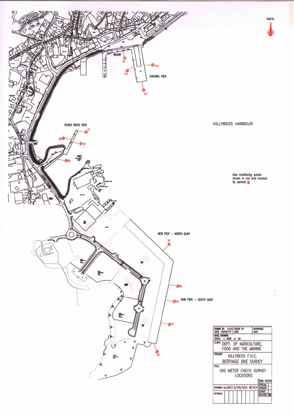
GAS METER CHECK SURVEY LOCATIONS
In order to rule out significant accumulation of spilled /decayed fish on the seabed adjacent to the berths, it was recommended that a localised dive survey be carried to examine the condition of seabed in the general area of the berths.
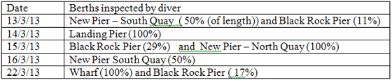
Dive inspections were carried out on 13-16/3/13 and on 22/3/13 as follows:
On site supervision was by the Engineering Division. For safe and effective diver based survey at each berth it was necessary that the berth should be completely free of vessels. Because the harbour was quite busy at the time significant input from Harbour Master was necessary to organise for relevant berths to be vacated in order for the dive survey work to proceed. The survey had to be spread out over an extended period as a result.
Killybegs Harbour Masters Office arranged for movement of vessels out of berths as needed and provided support and safety cordoning for the diving works.
The survey method adopted involved the diver walking the seabed along evenly spaced lines ( or transects) running parallel to the berth face and to record what was visible on the seabed along those lines. Typically these survey lines were 10 or 15 metres apart.
The location of diver survey lines are shown on attached DAFM drawing titled "Dive survey locations".
At the end of the 5 days of diving the seabed at the 4 landing piers for pelagic fish in the harbour had been inspected by diver - all of the New Pier, all of the Landing Pier and Wharf berths and 57% of the Black Rock Pier berths.
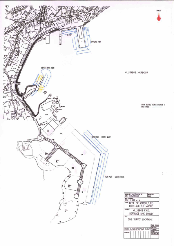
DIVE SURVEY LOCATIONS
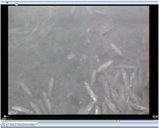
Sample frame from dive survey DVD record above showing scattered fish on seabed .
The surveying diver on seabed relayed information about what was visible on the seabed by radio to the supervisor on shore - this information included diver estimate of waste fish densities, sizes and depths of waste fish patches encountered - which were logged in real time along with the diver position . A camera on the diver's helmet provided a video record of the inspection ( see sample frame above). This video record on DVD was retained after the survey by DAFM.
The general findings of the diver survey are as follows:
1. Volumes of waste fish were found on seabed at all berths where fish were landed in recent months.
2. The waste fish found were often randomly distributed and found in low densities (typically 0.5 to 5 fish per square metre).
3. At all berths occasional small scale accumulations or patches (rarely exceeding 50 square metres) were found where there was coverage of the bed by waste fish.
4. No large scale accumulations were found.
5. Quantities found were broadly proportional to which berths were used most for landings of pelagic fish.
6. Fish species found were almost exclusively pelagic species with the vast majority being mackerel.
7. Location of fish at a particular berth seemed to be partly determined by bottom profile with largest accumulations in local depressions and in areas where water disturbance was least eg where propeller action was likely to be least or bed clearance under hulls was greatest.
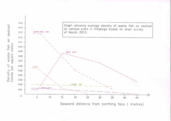
8. At most berths fish were found in highest concentrations immediately alongside berthing faces except at south quay of new pier where heaviest accumulations were found at 15-30 metres out from the berth face. ( see attached graph of average densities at the berths).
9. Some of the fish found were in advanced state of decay - possibly 2-3 months old.
Samples of the waste fish were taken to surface for species identification by SFPA.
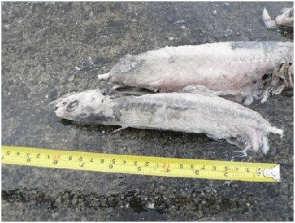
Examples of decayed mackerel recovered by diver from seabed 16/3/13
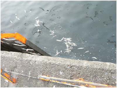
Example of waste fish carcases and parts floating on water surface at landing pier (probably
resuspended by trawler boat movement nearby) 14/3/13
DENSITY OF WASTE FISH ON THE SEABED
Based on the information provided verbally by diver during the survey which included dimensions of fish accumulations seen on the seabed and average numbers of fish per square metre, the volume of fish encountered by diver along each seabed line (or transect) may be calculated with a good accuracy. Note that over the 5 days of survey the divers viewed directly a total area of seabed of some 12479 square metres. This amounted to 30% of the total seabed area of interest at the berths.
Average depth of fish ( volume per unit area) along each survey (transect) line was also calculated. By interpolating between these values it was possible to work out estimates for depth of fish values for the areas of seabed lying between the transect lines and not seen directly by diver. This allowed estimated fish volume to be derived for this other 70% of the seabed area of interest.
Using this method total quantities of waste fish on seabed at each berth were calculated. These values may be considered as reasonably reliable based as they are on direct visual inspection of 30% of seabed involved and use of interpolation elsewhere.
The total volumes of waste fish found on the seabed for each surveyed line and the estimated volumes in between were calculated. When totalled they give an overall quantity for the seabed area adjoining each berth.
The total tonnages of waste fish on the seabed at the berths were estimated to be as follows :
New Pier : 825
Landing Pier : 155
Black Rock Pier : 184
Wharf : 51
TOTAL 1215